By Tracy Hames and Erin O’Brien for Wisconsin Trout Unlimited’s Summer 2020 Newsletter (page 26).
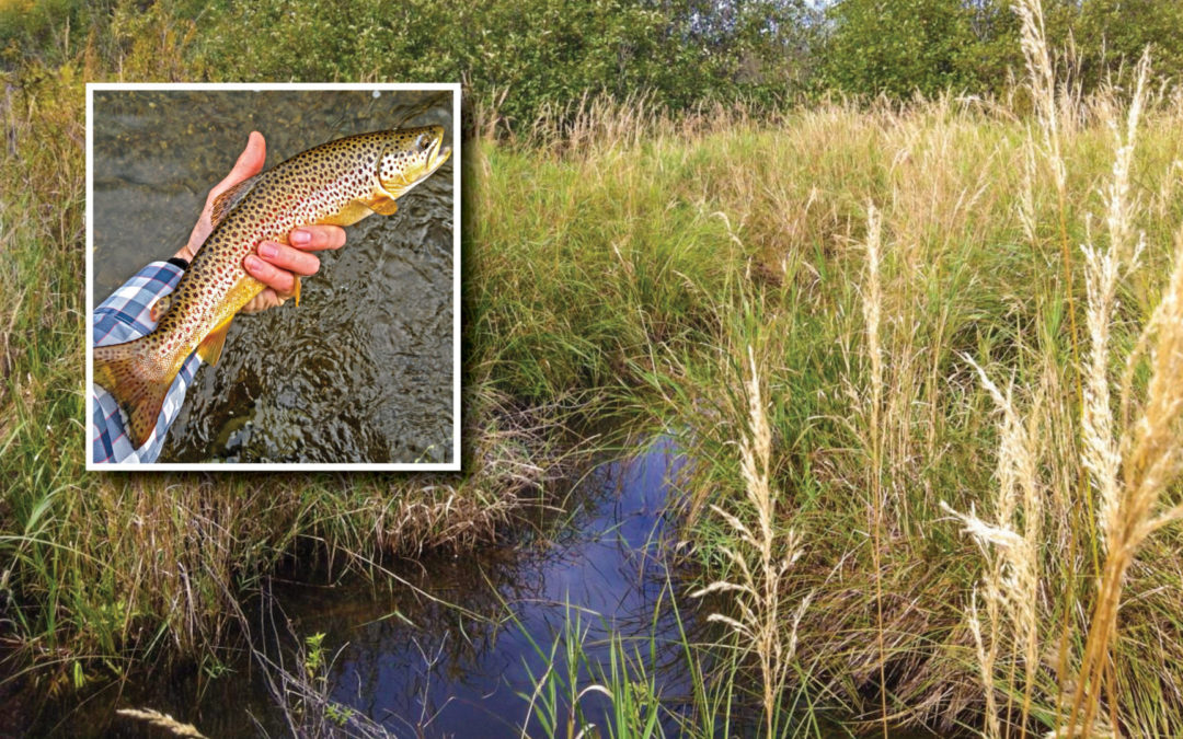
A few years ago, on a warm and sunny July day, I paid a visit to Bull Gus Creek; a Class One trout water in the Penokee Hills of Iron County. During my hike that day, I chanced upon an area where the creek snaked through a fairly large sedge meadow wetland complex. I approached its sinuous channel thinking I could catch a nice photo of the wetlands by standing in the creek. One step into the channel, however, brought me up to my neck in cold, cold water. Luckily, I’m an old duck hunter, skilled at keeping my gun out of the water. So the camera stayed dry.
Now, this experience didn’t make me mad — it got me excited.
The trout habitat at this location on Bull Gus creek is about as good as it can be. The channel is narrow and deep, helping maintain spawning gravels. Grasses and sedges stabilize undercut banks. The water is cold, with groundwater levels at or near the surface. And it winds through a broad, well-connected floodplain with the bonus of abundant wetlands from terrace to terrace.
It’s a striking contrast to many streams I’ve seen across Wisconsin where the water may still run cold but the physical condition of the channel is highly degraded. Eroded banks, incised channels disconnected from adjacent floodplains, and once-narrow streams that now run shallow and wide are but a few examples. Elsewhere, water temperature and supply may be compromised.
All of these degraded conditions affect trout habitat and all are tied to changes to watershed hydrology — in other words, how and when water moves through a watershed. The purpose of this article is to highlight how restoring wetlands in the upper reaches of our watersheds and reconnecting streams to their floodplains offers an effective but underutilized approach to restoring the health of Wisconsin’s coldwater fisheries.
So let’s start by reviewing two very basic needs of trout and how healthy upper watershed wetlands and healthy floodplains help meet these needs.
1. Trout need cold water
We all know that we can’t have trout if we don’t have cold water. Because Wisconsin summers are so warm, trout-bearing, coldwater streams rely on up-welling groundwater. That groundwater supply also helps buffer the effects of warmed surface runoff entering streams. Most groundwater originates from sources above the ground — especially snowmelt and spring rains. Upper watershed wetlands capture this melting snow and spring rainwater, slow it down, and allow it to infiltrate into the ground. The ground, acting like a refrigerator, keeps the precipitation cold as it makes its underground journey toward the stream. Though the snowmelt may have entered the ground in March, it will likely not reach the stream until the heat of the summer when the trout need this cold baseflow more than ever. Loss of wetland storage, whether through drainage or development, disrupts this infiltration and subsequent summer baseflow.
NECK DEEP AND NARROW: PERFECT TROUT HABITAT
Bull Gus Creek minutes after I stepped into the channel and sunk up to my neck. This narrow channel and sedge meadow floodplain help this creek maintain its Class 1 trout status.
2. Trout need healthy channel form and habitat structure
In many Wisconsin trout waters, healthy habitat conditions are characterized by deep and narrow channels underlain with gravels; undercut banks stabilized by fibrous-rooted grasses and sedges; and woody debris and other features supporting aquatic invertebrates and adding to structural diversity. Complex watershed-scale interactions between water, geology, geomorphology, and vegetation influence channel form and structure.
Wetlands affect channel form in two important ways, both related to the energy of flows.
When upper watershed wetlands capture and slow the flow of runoff, the energy of the runoff is reduced. But when upper watershed wetland storage is removed, water moves swiftly across the land in the form of unnaturally large, short duration (flashy) runoff events. These high-energy, flashy events cause large amounts of erosion.
To accommodate these flashy flows, the channel must change its shape. Channels generally change their shape in two ways. One way is by digging themselves deeper into the ground. This is called incision and is very common in trout streams across Wisconsin. Another way is by making themselves wider and shallower. This condition is more common in trout streams in the Central Sands region. As channels change their shape to accommodate flashy runoff events, they become increasingly disconnected from their floodplains.
When a stream becomes disconnected with its floodplain, the energy associated with the runoff stays in the channel. This increases bank erosion and downstream sedimentation, causing further disconnection of the channel from its floodplain. With each runoff event, conditions get worse — tributary channels become gullies, floodplain disconnection increases, spawning gravels become buried in sediment, summer baseflow is reduced, bank habitat is lost, and the stability and complexity of the channel suffers.
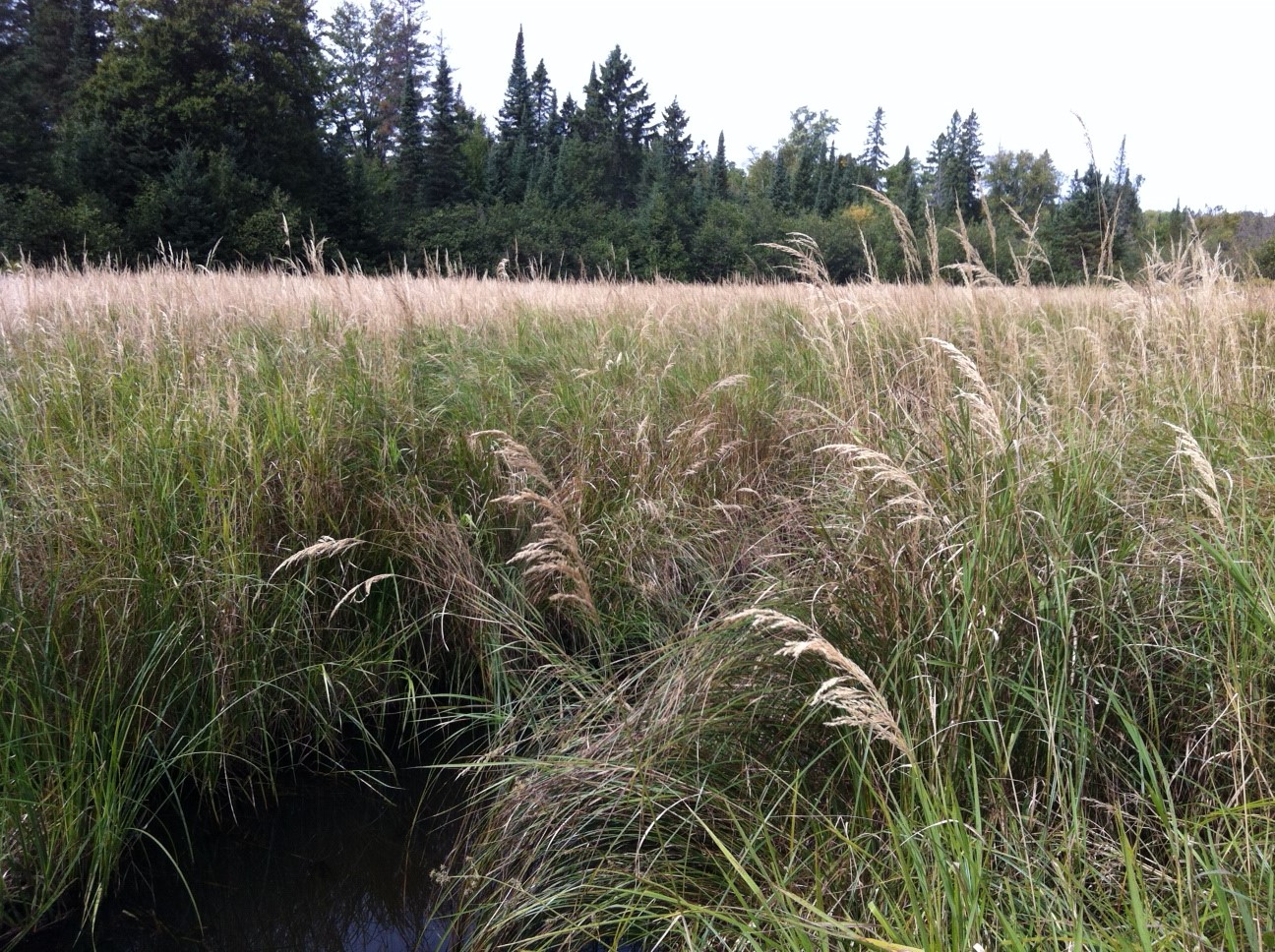
BULL GUS WETLAND AFTER FLOODING
An upper watershed wetland in the Bull Gus watershed in July 2016, a couple of days after a historic event dropped more than 11 inches of rain throughout the region. This rain event caused more than $35 million in public infrastructure damage. Thanks to the thousands of wetlands like this capturing runoff, there was minimal damage in the Bull Gus watershed.
Back to Bull Gus Creek
Remember the high-quality site where I went in up to my neck? Walk up from that site and you’ll find wetlands covering nearly 50% of the upper watershed, effectively capturing runoff and reducing the energy of the 200-250 inches of snow that falls there each winter (that’s a lot). The large sedge meadow floodplain where I took a dip further reduces the energy of the water flowing from above. The combined energy reduction helps keep the channel stable, deep, and narrow — great habitat for trout. It’s an amazing place, and one of my favorite landscapes in Wisconsin.
Connecting hydrologic restoration to habitat recovery and resilience
I’ve spent much of my career protecting, restoring, and managing large acreages of habitat in coldwater salmon- and trout-bearing watersheds. Over the decades I’ve learned much by watching, living with, and managing the properties I’ve restored. Many of you also have long-term knowledge of the waterways you help protect, restore, manage, and fish.
Now, we’ve all worked on projects where the objective is to fix something that’s messed up at a given site. And we’ve all worked on projects where for one reason or another what we tried didn’t stick. At least I know I have.
One of the most important things I’ve learned from these experiences is that the more degraded the hydrology is upstream from a site where I’m working, the harder it is to achieve self-sustaining restoration goals on that site. So, after decades of careful attention, when I approach a restoration effort today, I always ask the same three questions:
- How did water historically move through this watershed?
- What’s changed over the years to alter that movement and how do those changes affect this site?
- What can we do to restore some semblance of historical water movement in a modern context?
The take-home is that keeping your favorite fishing spot healthy may require work upstream. In some places, re-establishing wetland storage and infiltration and reconnecting streams to historic floodplains might give you the biggest bang for your restoration buck in the long run. This is especially important given the increasingly intense precipitation events we are experiencing in Wisconsin. Because a hydrology-based watershed approach to habitat restoration also helps reduce flooding and runoff and conserves soil, integrating these practices can further increase public investment and community engagement in your restoration work. Restoring watershed hydrology with these co-benefits in mind is the root of an exciting new collaboration between WWA and Trout Unlimited staff in Northern Wisconsin (see below). We’ll have much more to report on this collaboration soon, so stay tuned!
WWA and TU team up on watershed restoration
Wisconsin Wetlands Association, Wisconsin Trout Unlimited, Ashland County, and many others have teamed up in the flood-prone Marengo River watershed of Northern Wisconsin to develop and implement a pilot watershed approach to hydrologic restoration.
Together, we’ll be exploring opportunities to strategically improve upper watershed wetland storage and floodplain connection in order to sustainably improve fish habitat and passage, reduce flooding, and protect vulnerable infrastructure.
The watershed approach being developed with this partnership is drawing much attention and support, with funding coming from sources focused on habitat, healthy forests, hazard mitigation, climate change, and more.
Even the Wisconsin Legislature recognized its value, providing $150,000 toward the planning and construction of demonstration projects to show how upper watershed and floodplain wetland restoration can help address water management issues in light of increasingly strong storm events.
This legislation, 2019 Act 157, passed with unanimous bi-partisan support before being signed by the Governor. Both WWA and TU lobbied in support of this bill.
For more information on this partnership, please contact WWA’s Kyle Magyera at kyle.magyera@wisconsinwetlands.org or TU’s Chris Collier at chris.collier@tu.org.
Related content

Healthy trout streams need healthy wetlands
What do isolated wetlands have to do with trout habitat? The answer is, a lot!


Wetland Coffee Break: Starhead Topminnow: The rare star of the backwaters of the Lower Wisconsin Riverway