By Nelson Ham, professor of geology and environmental science, St. Norbert College
Wetlands are never islands unto themselves. They form an important part of the hydrologic cycle that transfers surface and groundwater through watersheds. Even wetlands with no surface outlets are connected—they exist through the flow of groundwater into and out of them. In Wisconsin, we owe much of our modern hydrologic landscape of wetlands, ponds, lakes, streams, and rivers to the last ice age, when a vast ice sheet reshaped the land, left behind thick glacial deposits, and ultimately reorganized surface and groundwater systems. To really understand the connections between Wisconsin’s wetlands and our waters, we need to visit our ice age past and study the glacial landscapes in which they initially formed thousands of years ago—and still exist today.
The last major ice age in North America—the Wisconsin Glaciation—is named after our state. The Laurentide Ice Sheet was the larger of two ice sheets that covered most of Canada and, along its southern margin, flowed through the Great Lakes basins into the Midwest. The glacier’s behavior was complex, but in general, the ice covered large parts of northern and eastern Wisconsin starting about 30,000 years ago and finally melted out of the state about 10,000 years ago.
Many Wisconsinites are familiar with glacial landforms such as moraines, drumlins, and kettles. The impact of those landforms and their deposits on surface and groundwater is what interests us here. Glaciers are famous for the ways they reorganize drainage systems. The tendency is for glaciers to form landscapes with many closed depressions, few through-flowing streams, and thus initially poor drainage, creating a landscape that initially doesn’t drain very well. Perfect conditions for developing wetlands. Let’s explore how.
First, as a glacier flows across the landscape, it collects and moves sediment at its bottom. The marginal zone (edge) of a glacier can become loaded with debris and rocks from bottom to top. That sediment often accumulates on the glacier’s surface as the glacier starts to retreat; this sediment insulates the ice beneath it. Once the ice buried underneath this sediment and debris melts, countless depressions surrounded by hilly terrain are left behind. That was the case for many moraines that formed along the edge of the ice sheet in Wisconsin, and spectacularly so in the largest terminal moraines that range from near Antigo in Langlade County, WI, westward into Minnesota (compare Figure 1 to Figure 2 to see this for yourself).
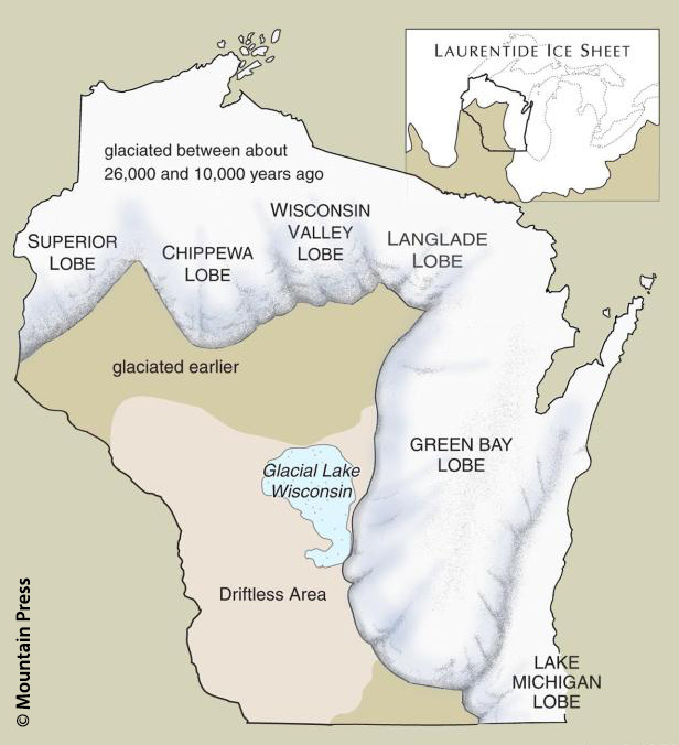
Figure 1: The Laurentide Ice Sheet’s extent into Wisconsin.
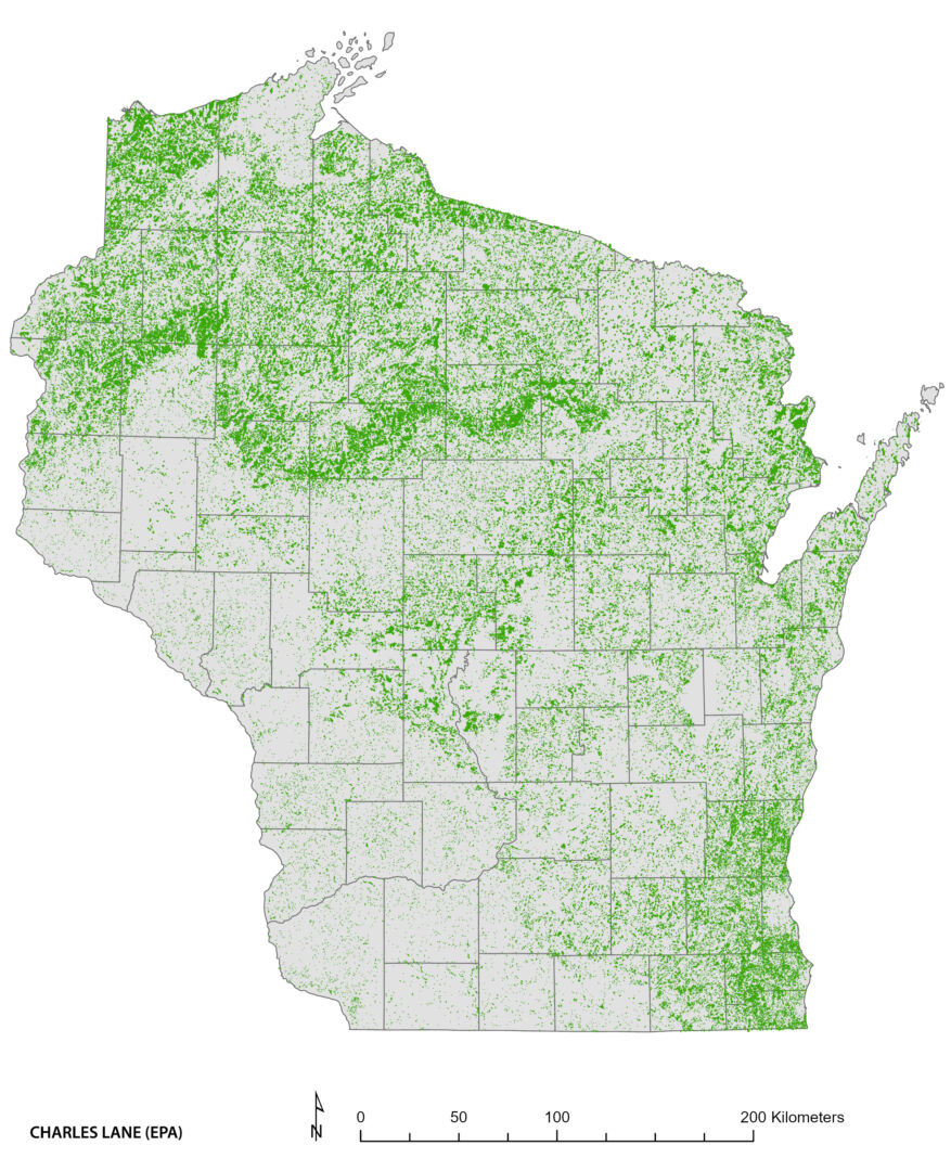
Figure 2: The depressions made by melting glaciers are now internally-draining wetlands shown here in green. Notice how the concentration of these wetlands in the northern part of the state follows the edge of the Laurentide Ice Sheet in Figure 1.
Second, as the glacier melts away, blocks of ice often are stranded from the main glacier and become surrounded or buried by sand and gravel deposited by meltwater rivers. When that stagnant ice finally melts, we are left with kettles— more closed, poorly-drained depressions that don’t always have an obvious surface connection to nearby waters. Wisconsin has a seemingly infinite number of kettles in the glaciated regions of northern and eastern Wisconsin, many of them filled with wetlands.
Lastly, as the ice sheet advanced and retreated over northern and eastern Wisconsin several times, it formed many ice-marginal lakes that are now long gone. The Central Sands of Wisconsin and the flat landscape of the Fox River Valley owe their existence to two of the largest and now extinct lakes—Glacial Lakes Wisconsin and Oshkosh. It’s probably obvious that glacial-lake landscapes should have poor drainage owing to their flatness and thus form wetlands. In Wisconsin, many of those wetlands were drained for agriculture by Euro-American settlers.
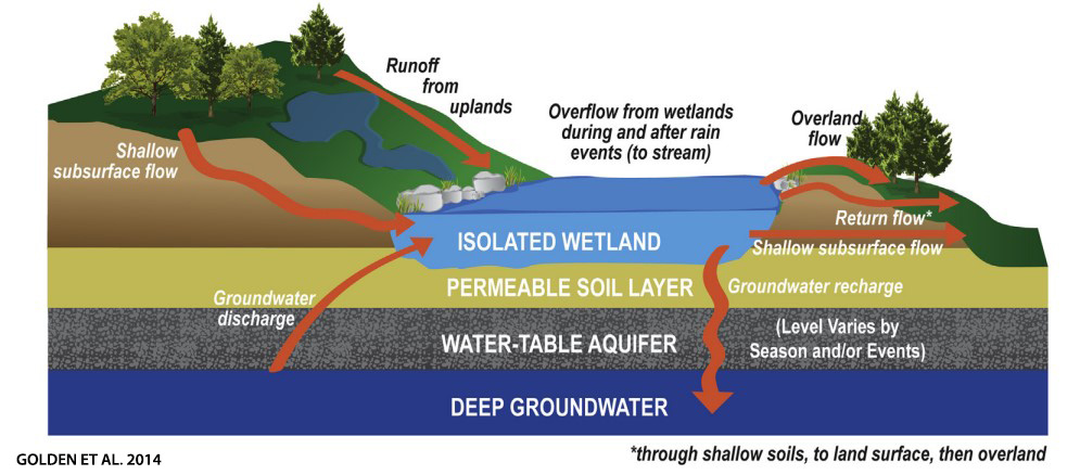
Figure 3: Internally draining wetlands (also sometimes referred to as ‘isolated’ wetlands) may appear disconnected from other waters at the surface, but they have important connections to groundwater, shallow subsurface flows, and even runoff or overland flows during rain events.
In the post-glacial climate of Wisconsin, the water table stabilized close to the surface in the depressions of countless hilly moraines, kettles, and former lake plains across our state—forming spectacular and diverse wetland landscapes. But it’s important to remember that glaciation doesn’t account for all of Wisconsin’s wetlands. Many of those along rivers and streams developed after glaciation as part of normal stream processes and the return of life to a once-frozen landscape (think beaver!). But that’s a story for another time.
How does a Wisconsin wetland connect to its immediate landscape and broader watershed? What conditions formed and sustain it? How do we best restore wetlands? Our ice age past helps us to answer those questions as the Wisconsin Wetlands Association looks to a promising future of wetland conservation.
Related content

From the Director: Our waters and wetlands are connected


Wetland Coffee Break: Implications of the Sackett decision for Wisconsin: Early takes from the front lines